

Observation strategy
The observation mission of the AMMA-CATCH observatory consists of long-term documentation of the critical zone in West Africa. These observations contribute to the 3 thematic axes of the SNO.
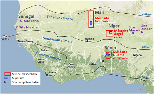
Since 1990, the observatory has relied on 3 mesoscale sites (≈100x100 km²) to document the North-South climatic gradient characteristic of the region. On each mesoscale site (in red on the map), finer observations are made on "supersites" (in blue on the map). List of meso-sites and supersites.
To study the longitudinal gradient which tends to strengthen, AMMA-CATCH has set up since 2016, complementary sites (in purple on the map) which rely on the infrastructures of AMMA-CATCH scientific partners . List of complementary sites.
Mesoscale sites
Three mesoscale sites (≈100 * 100 km²) have been equipped to sample contrasting regions : by their climatic and ecological zone, their geography, their hydrological functioning, land use and development. These sites are dedicated to the study of the coupling between vegetation dynamics and the water cycle, continent-atmosphere feedbacks and water balance estimates.
On each of the mesoscale sites, the observation strategy is based on a nested multiscale approach which includes :
- A "super-site" (typically 100-1000 km2) dedicated to process studies at intra-seasonal to inter-annual time scales on an integrating hydrological domain
- local sites (1 km2) dedicated to the detailed documentation of the components of water and energy cycles and their coupling with the dynamics of the vegetation typical of this climate.
| Country | Meso-site | climate | supersites | local sites |
| Benin | Ouémé Upper Valley (14 000 km²) |
sudanian climate precipitation 1200-1300 mm/year |
Donga Basin watershed (600 km²) |
Nalohou (cultivated area) (≈ 20 ha) Béléfoungou (Woodland) (≈ 20 ha) Bira (fallow) (≈ 20 ha) |
| Niger | Niamey Square Degree (16 000 km²) |
sahelian climate precipitation 450-600 mm/year |
Central Niger Fakara (2000 km²) |
Wankama watershed (1 km²) Tondi Kiboro watershed (< 35 ha) Mele Haoussa watershed (< 35 ha) |
| Mali | Gourma (30 000 km²) |
sahelian to saharian climate precipitation 200-400 mm/year |
Hombori (2500 km²) Agoufou pond (250 km²) |
Complementary sites
In addition to the meso-sites, the AMMA-CATCH network includes 4 complementary sites, 2 of which are located in Senegal and 2 in Niger. Each of the sites includes a common minimum measurement dataset to study regional variability (rain, radiation balance, water table height).
| Country | Complementary Site | Climate | Land use | Scientific Partners |
| Sénégal | Ferlo (25*25 km²) |
sahelian to saharian climate precipitation 200-400 mm/year |
Pastoralism | ISRA (CRZ), Univ. Copenhague, Lund, Karlsruhe |
| Sénégal | Niakhar (25*25 km²) |
sahelian climate precipitation 400-600 mm/year |
Agroforestry | Univ. UCAD, UMR Eco&Sols |
| Niger | Maradi (25*25 km²) |
sahelian climate precipitation 400-600 mm/year |
Assisted Natural Regeneration | Univ. UDDM, JEAI PRESAF |
| Niger | Zinder (25*25 km²) |
sahelian climate precipitation 400-600 mm/year |
Agro-pastoralism | Univ. Zinder, PANGIRE project |
