Structuring
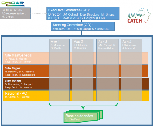
The observatory is structured according to two dimensions, one geographic, which manages the observations (Mali / Senegal, Niger, Benin sites and regional scale) and the other thematic, which organizes the production of knowledge, according to four axis : (1) multi-decadal trends in hydro-climatic hazards (past / projections) ; (2) vegetation and land use dynamics, and their interactions with the water cycle ; (3) trajectories of water resources (quantity / quality, past / projections) and (4) metrology, technological watch and innovation for observation in intertropical zones. The functional organisation chart takes both dimensions into account :
Executive Committee (EC)
Around the director of the observatory, the Executive Committee (EC) brings together 3 co-directors, who represent the UMR HSM and GET who co-run the observatory in the North, and a representative appointed by the partner institutions of the South. The EC is an “agile” body capable of reacting quickly to requests and responsible for monitoring the decisions taken by the steering Comitte. It meets at least once a month. He is assisted by a steering committee.
Steering Commitee (SC)
The Steering Commitee (SC) is made up of those responsible for the axes and the site captains and the EC. The SC meets every 2 to 3 months, makes arbitrations on the strategy of the observatory and the distribution of budgets, and ensures the follow-up of the work of the groups and axes. The SC also organizes the annual scientific days, a key moment in the scientific animation of the observatory during which the latest scientific results are presented. Part of the program of the days is devoted to forward-looking and strategic thinking.
Research axis Managers
The thematic axis are steered by North-South pairs, responsible for coordinating research relating to each theme at intersites, maintaining an overview of the observation protocols deployed on each site, and ensuring coordination in and between thematic axes. Each axis can take up a scientific and / or methodological question in order to enhance the data from the observatory.
Site Captains
The sites are managed by a North-South partnership (site “captains”), responsible for the scientific and logistical coherence of the instrumental network. They coordinate the field actions necessary for the development of the observation system, the budget request according to the instruments deployed and they are responsible for the financial management of the site. They also ensure coordination with measures that are not part of the observatory. The site managers ensure that the database is properly fed with the observations collected on their site.
Regional officials lead initiatives that go beyond observation sites. This includes on the one hand the aggregation of data from other institutions or projects, data rescue, etc., and on the other hand satellite data and products or even regional model outputs.
Principal Investigator (PI)
The PI is responsible for a dataset. The PI determines the observation strategy and the associated budget. He writes and updates the instrument sheet every year. He is in charge of the quality control of the data before their annual sending to the person in charge of the database. He is automatically informed of the downloading of the data for which he is responsible. The financing of an instrument is subject to filling the database with data validated by the PI.
Database administrator
The database manager manages the database and its development. She coordinates with the other data centers (OSUs, IR, Theia Pole, etc.). She makes an annual call to PIs, checks the compatibility of the data and integrates them into the database
Updated on 26 janvier 2022


